Purpose of this Blog
This blog is hybrid of a photographic record of the destruction caused by Hurricane Katrina, an analysis of the events leading to the Katrina tragedy, and an inquiry into the appropriate response to Hurricane Katrina. I hope to put Hurricane Katrina into the larger context of emergency response, as well as the necessary adaptations to global warming.
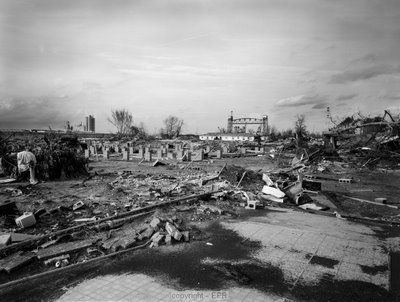 This is a view of the 9th Ward in New Orleans, about 300 feet from the levee break on the Industrial Canal.
 This is a view of the 9th Ward in New Orleans, about 300 feet from the levee break on the Industrial Canal.
posted by Edward Richards at
9:41 PM
0 Comments
![]()